|
The
World's Best
Electronic Charts!
Each
Passport Deluxe Chart Region Includes Nobeltec's Visual GPS Planner
for Route Planning & GPS Upload/Download.
Passport
Deluxe is the only electronic charting package that includes digitized
version of both raster and vector official NOAA charts.
Most US regions also includes data such as Nobeltec Navigation
Photos, USGS Topo Maps, Coast Pilots, a marine facilities database,
light list, and much more! Passport
Deluxe will work with any Nobeltec Navigation program, including the
Visual Navigation Suite, Visual Mariner, and Nobeltec Admiral. These
regions also include a copy of Nobeltec’s Visual Planner software so
you can plan your trip with unlimited routes and waypoints, and even
send and receive them to and from your computer and GPS.
Passport
Deluxe regions will work with any Nobeltec Navigation software 6.0 or
higher, or as a stand-alone planning program.
For
US Waters,
Passport Deluxe is the only electronic charting package that
includes digitized versions of both raster and vector official NOAA
charts. Each US region also includes data such as Nobeltec Navigation
Photos, USGS Topo Maps, Coast Pilots, a Ports and Services database,
Tides & Currents for the region, and much more! (Aerial photos
& USGS Topo Maps not available for all regions. Check region
box for availability.)
•
US
Regions:
$249 (call for pricing on multiple
region bundles!)
Passport
Deluxe Bahamas/Bermuda (covers
Bahamas, Bermuda, Abacos, Exumas & Turks and Caicos Islands).
Nobeltec
now has the best electronic chart coverage ever offered in one box for
the Bahamas. Each region is packed with navigation data including
vectorized versions of the Dodge, Explorer and Wavey Line paper
charts. In addition, Passport Deluxe Bahamas also includes 15 meter
satellite and aerial photos for the entire Bahamas and sub-meter
navigation photo charts for popular cruising areas. No other
electronic chart package offers this level of detail and clarity.
•
Bahamas/Bermuda
Region:
$349
Passport
Deluxe Canada are simply the best electronic charts for navigating
Canadian waters. Each Passport Deluxe Canada region contains loads of
navigation data including vectorized versions of the official CHS
charts for Canadian waters, satellite and aerial pictures, tide and
current information, a Ports Services database and much more! From
coastlines and buoys to depth soundings and nav-aids, Passport Deluxe
Canada allows you to reach your destination with confidence.
•
Canadian
Regions (P1 or P2):
$299
Passport
World Charts have worldwide coverage with over 6,500 available
charts. These intelligent vector charts were created using data from
worldwide hydrographic offices including NOAA and the British
Admiralty. Passport charts contain all the information you need for
safe and easy navigation here at home or around the globe.
•
Small
International Folios: $299
•
Large
International
Folios: $449
•
USB
or LPT Dongle Required International Charts: $49.99
•
Call
for pricing on large bundled international zones.
Passport
Bathy Maps bring your surrounding to life in full 3D! Used
as an extra aid to navigation, they provide valuable information about
your surrounding environment. When used in conjunction with Passport
Deluxe, you can now take advantage of Nobeltec’s new Chart Draping
technology.
This feature allows you to overlay an electronic chart on top
of a 3D grid for unsurpassed navigation information. Passport Bathy
Maps also allow you to use the Automatic Route Wizard found in
Nobeltec Admiral and Visual Navigation Suite. Whether you are a
fisherman looking for the perfect spot, a boater navigating in
unfamiliar waters, or a professional that makes a living around the
water, Passport Bathy Maps provide you with the information you need
to navigate safely.
•
Continental
US Regions:
$249
• Alaska
Regions:
$449
•
Call for pricing on multiple region bundles!
| |
| Nobeltec
Software Minimum System Requirements |
| • |
Microsoft®
Windows® 98, ME, 2000 or XP |
| • |
Pentium®
III 450 MHz or equivalent |
| • |
128
MB RAM |
| • |
16
MB video card |
| • |
100
MB available had disk space (additional space required for charts
or other data) |
| • |
16
bit color VGA-compatible display (or better) |
| • |
For
VNS & Admiral: Available serial port or USB for GPS
connection;
If
you do not have an available serial port, we can supply either a
USB or PCMCIA to serial adapter. |
| • |
Available
USB or parallel port |
| • |
12x
or higher CD-ROM drive |
| • |
Mouse
or other pointing device |
| |
| • |
Recommended:
Microsoft Windows 2000/XP Pro, Pentium III class 1.0 GHz with 256
MB RAM or better, 64 MB (or better) high-end 3D video graphics
card with OpenGL capabilities and a GPS or Loran receiver. |
| |
|
|
|
Passport
Deluxe Charts Regions can be used with their included GPS
Planner software, or with Nobeltec's full featured electronic
charting programs,
Visual Navigation Suite or Admiral. |
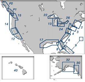
US/NA
Passport Deluxe Region Breakdown:
|
Passport
Deluxe Included Data:
V= Vector Charts P= Nav
Photos
R= Raster Charts D= Data
Pack
T= Topo Maps |
V |
R |
P |
D |
T |
| Region
2: Block Island, RI to Canadian Border |
X |
X |
X |
X |
X |
| Region
3: New York - Nantucket - Cape May, NJ |
X |
X |
X |
X |
X |
| Region
4: Chesapeake & Deleware Bays |
X |
X |
X |
X |
X |
| Region
6: ICW - Norfolk, VA to Jacksonville, FL |
X |
X |
X |
X |
X |
| Region
7: Florida East Coast & Keys |
X |
X |
X |
X |
X |
| Region
8: Florida West Coast & Keys |
X |
X |
X |
X |
X |
| Region
9: Bahamas & Bermuda |
X |
X |
X |
X |
|
| Region
10: Puerto Rico & US Virgin Islands |
X |
X |
|
X |
|
| Region
12: Southern California |
X |
X |
X |
X |
X |
| Region
13: Lake Michigan |
X |
X |
X |
X |
X |
| Region
14: San Francisco to Cape Flattery |
X |
X |
X |
X |
X |
| Region
15: Puget Sound |
X |
X |
X |
X |
X |
| Region
17: Gulf Coast - Mobile, AL to Mexico |
X |
X |
X |
X |
X |
| Region
22: Lake Superior & Lake Huron |
X |
X |
|
X |
X |
| Region
24: Lake Erie |
X |
X |
|
X |
X |
| Region
26: Lake Ontario |
X |
X |
|
X |
X |
| Region
30: Southeast Alaska |
X |
X |
X |
X |
X |
| Region
32: South Central Alaska, Yakutat to Kodiak |
X |
X |
X |
X |
|
| Region
40: Hawaiian Islands |
X |
X |
|
X |
X |
| Region
P1: Inside Passage of Vancouver Island |
X |
|
X |
X |
|
| Region
P2: Hecate Strait to Portland Canal |
X |
|
X |
X |
|
|
NOBELTEC
CHARTING PRODUCTS COMPARISON TABLE
P = Planner/All Products T
= Tides & Currents
S= Visual Navigation Suite
A = Admiral |
| Features |
P |
T |
S |
A |
|
| |
|
|
|
- ALL
SOFTWARE PRODUCTS FEATURE:
- Geo-Draw
Charting Engine
-Supports Passport Deluxe Regions, World Charts & Bathy Maps, and
all popular raster charts & aerial photos
- Quilting
for seamless charts
- Customizable
Toolbars and Nav Console
- USB
Dongle support
- Route
Trip Tick printing option
- Free US
Planning charts
- Unlimited
routes, marks and waypoints
- 3DNavigator
included
- Free
Weather overlay support
- GPS
upload/download
|
X |
X |
X |
X |
|
- TIDES
& CURRENTS - All the Above Plus:
Includes full copy of Tides & Currents
-Predictions
to 2100; Tide and current overlay on chart; Currents aware ETA
Calculator; Sunrise, sunset, moonphase, & more data; Powerful
tidal reporting
|
|
X |
X |
X |
|
- VNS -
All the Above Plus:
- Course
Up/North Up chart rotation
- Real-time
GPS Navigation
- NavBar
- Autopilot
& external NMEA support
- Twilight
and Night Vision
- Automatic
RouteWizard
|
|
|
X |
X |
|
- ADMIRAL
- All the Above Plus:
- Customizable
vessel sizing
- Track
line coloring w/ incoming NMEA data
- World
Chart Dongle
- NavView
- Vessel
Management Software included
- ARPA and
MARPA Radar support
|
|
|
|
X |
|
| TO
ORDER: |
 |
|
or
call: |
|
1(800)483-8100,
(outside NY Metro),
or 1(516)482-8800 |
|
|

)
)
)